The last stop on our Interrailing trip was the city of Marseille, located on the south coast of France. Despite spending less than 48 hours in Marseille, we still managed to complete two hikes in the nearby Parc National des Calanques. This stunning coastal area was the main reason we’d chosen to visit Marseille, so I was relieved to learn the weather conditions allowed for the park to be open during our visit.
If you're planning a trip to the national park, we would suggest first visiting the Tourist Information Centre in downtown Marseille to pick up some maps of the park's many trails so you don't get too lost.

Luminy to the Calanque de Sugiton & Belvédère de Sugiton
Start & end point: University campus in Luminy
Distance: ≈ 8.5 kilometres
Difficulty: Moderate
At around 17:00, we set off from the university campus and (after getting slightly lost) finally found our way onto the trail. Hiking in early June, the evening temperature was much more manageable than it had been in the afternoon, but we still appreciated the shade of the forest during the first part of the hike. We were one of the few groups setting off that late – everyone else we saw was heading in the opposite direction, back towards Luminy.
Emerging from the forest, the view out towards the sea was revealed. The dramatic cliffs, interesting geological features and gorgeous blue seas reminded me of being on the South West Coast Path back in Devon.
At the Col de Sugiton, we reached an intersection in the path. We had wanted to take the short cut, but after incorrectly deciphering the French signs, we ended up following the main path down towards the coastline. For the majority of the hike, the wide gravel trail was well maintained and easy to navigate. As we got closer to the sea, however, we left the main path and joined a steep, rocky trail that required more care and concentration to descend. Hiking in the early evening was a great decision as good portions of the trail were shaded from the direct sunlight by the surrounding hills.
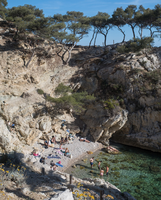
Around an hour after starting the hike, the Calanque de Sugiton came into view. The turquoise waters and sunny beaches were just as beautiful as I had imagined. The main beach was small and fairly crowded, so I can only imagine how packed it must have been earlier in the day!
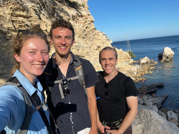
We continued along the path above the beach before descending onto the rocky shoreline around the corner. Brett and I went for a swim, admiring the sailboat anchored in the calm waters near the nude beach. It was my first swim since being stung by a jellyfish in Menton, so I was a little apprehensive about getting back in the water. Luckily, the swim was jellyfish-free, and we could enjoy the beautifully clear water and dramatic cliffs rising up out of the water on the other side of the bay.
After getting out and drying off, we ate our picnic dinner on the rocks – a proper feast featuring fresh baguettes with smoked tofu, tomatoes, ratatouille and vegan sandwich meat. French bread really is on a whole other level.
After eating, we made our way back up out of the Calanque and hiked towards the Belvédère de Sugiton, which offers sweeping views over the dynamic coastline. The white limestone cliffs were illuminated in a warm glow from the setting sun.
The sunset made for a dramatic moment to be at the viewpoint, although we didn’t stay for too long because it was incredibly windy at the top!
As darkness began to fall, we retraced our steps back to the Luminy university campus and caught the bus back to Marseille.

Getting to the start from Marseille: Take the M2 metro to the Rond Point du Prado station, transfer to the B1 bus to the Campus de Luminy
Useful map of the Luminy area: http://www.calanques-parcnational.fr/sites/calanques-parcnational.fr/files/atoms/files/carte-luminy.pdf
Calanque de Callelongue to Les Baumettes
Start point: Calanque de Callelongue
End point: Les Baumettes
Distance: ≈ 10 kilometres
Difficulty: Easy first half, strenuous second half
On our second day in Marseille, I was eager to get back to the Parc National des Calanques. After a successful first hike, we decided again to wait until later in the afternoon to set off, so that temperatures would cool down throughout the hike. Back at the Airbnb, we agreed to attempt the red-white route as it would take us past multiple calanques and seemed manageable to complete in an afternoon. And so, with our bags packed full of fresh water, a packed dinner and our swimsuits, we caught public transport out to the start of the hike.
The minibus dropped us off at the Calanque de Callelongue, the first calanque in the Marseilleveyre massif. It was easy to find the start of the trail and at 16:00 we began hiking across the rocky coastal landscape, following the red and white trail markings.
The second calanque we came across was the Calanque de la Mounine, a tiny inlet in the rocky shoreline. I couldn't resist going for a swim, although the shallow water made it difficult to swim for long.
The first few kilometres of the hike were wonderfully flat, the trail winding through the Mediterranean landscape, just metres from the coast. The views were always spectacular, helped of course by the sunshine and blue skies. There wasn't much shade on this first stretch of the route, but the temperatures weren't unbearable.

The third calanque, the Calanque de Marseilleveyre, featured a large white sand beach. Brett joined me for a swim while Paul relaxed on the shore. If you’re looking for a less intense day-hike, you could hike out to this Calanque and then turn around and hike back to the start.
By the time we had reached the Calanque des Queyrons, the fourth calanque of the day, it was 17:45. We were surprised to find only one other group on the rocky shoreline. I went for another refreshing swim and enjoyed getting to jump off one of the rocks into the crystal blue water.
Half an hour later we reached the last calanque of the day – the Calanque de Podestat. We followed the green trail down the side of the ravine and emerged onto the beach, where we were delighted to find we had the whole Calanque to ourselves! Unfortunately, we still had a significant way to go to reach the end of the hike, so there was no time for a swim.
From here, the trail began to climb some serious elevation and our quick progress slowed substantially. At one point, we tried to follow the Green trail, however we quickly turned around after the trail appeared relatively unused and I began to feel unsafe. As we continued on the red-white trail, we were entirely alone on the cliffs and I was starting to get nervous about being out on the trail after dark. We also had to make it back to civilisation before the last bus of the evening...it was going to be tight.
The elevation gain was draining, but luckily the heat wasn't too intense as we were getting into the evening. After making it up to the crest of the cliffs, we stopped to eat our picnic dinner. To our left, we could see Marseille in the distance and to our right, the open sea. From there, we followed the trail down to the road, where we picked up the Brown trail and hiked into Les Baumettes. Luckily, we make it back into civilisation with just a few minutes to spare before the last bus of the evening. What a wonderful adventure to end our Interrailing trip!
Getting to the start from Marseille: Get the Metro 2 to Rond Point du Prado, then catch bus 19T and transfer to bus 20 at the last stop
Useful map of the Marseilleveyre area: http://www.calanques-parcnational.fr/sites/calanques-parcnational.fr/files/atoms/files/carte-marseilleveyre.pdf
General Resources:
In the summer, the park is only open in favourable weather conditions. Check whether it is open for hikers before you go: http://bpatp.paca-ate.fr/
For an overview of the national park: http://www.calanques-parcnational.fr/en
Details of different hiking trails: http://www.calanques13.com/en/hiking-trails-calanques.html
Hiking trail map of the Parc National des Calanques: http://www.calanques-parcnational.fr/en/map-library


